
By Steve
When you spend your life working in water treatment, you get used to looking at water through a microscope or a lab report. You talk about parts per million, total dissolved solids, filter micron ratings, and pipe friction loss. It is a precise world built on chemistry and fluid mechanics.
But if you spend enough time out in the field — talking to well drillers, farmers, and old-timers who have lived on the same plot of land for generations — you eventually run into a practice that does not fit neatly into a textbook.
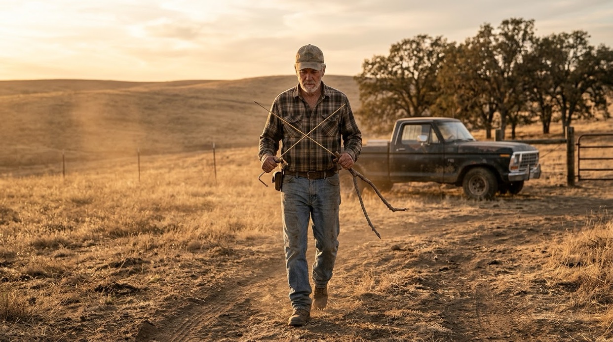
You will see a man step out of a pickup truck holding two thin, L-shaped brass rods, or maybe a Y-shaped fork cut from a peach tree. He will grip them loosely in his hands, hold them straight out in front of his chest, and start walking across a dry pasture. Suddenly, without his hands visibly turning, the two brass rods cross over each other like a pair of scissors.
He stops, points his boot at the soil, and says, “Dig here.”
That is water dowsing — sometimes called water witching, divining, or doodlebugging. Depending on who you talk to, it is either an ancient trade tradition, a subconscious skill, or outright nonsense. Having spent my career helping folks understand what is in their water and how it gets to their tap, I have always found the tradition fascinating.
Here is a plainspoken look at what dowsing is, where it comes from, what science has to say about it, why it has refused to disappear — and how the professionals find water today, when the rods stay in the truck.
What Is Water Dowsing?
At its core, dowsing is the practice of using a hand-held tool to locate underground water, minerals, or utilities.
While some people use pendulum weights or wooden sticks, the most common setup you will see today involves two L-shaped metal rods — usually brass, copper, or steel cut from old coat hangers. The short end of each “L” is held loosely in the hand, often inside a light sleeve or tube so the rod can pivot freely, while the long end points forward.
The dowser walks slowly across the terrain. When they pass over what they believe is an underground stream or aquifer, the tips of the rods swing inward and cross over one another. Some dowsers claim they can feel a slight magnetic pull; others say their hands get warm or feel a subtle twitching sensation.
A History Measured in Centuries
Water witching is not a modern fad. People have been walking fields with sticks for hundreds of years.
Historical woodcuts and documents show miners and farmers using wooden divining rods across Europe. Originally, the practice was used to locate silver, copper, and iron ore seams deep underground — the oldest written accounts come from German mining country, where the forked rod was a working tool of the ore hunters. Over time, as communities expanded and needed reliable drinking water for livestock and farming, the technique was adapted to find underground water sources.
When European settlers migrated to North America, they brought the tradition with them. On the American frontier, finding a good spot to dig a well was a matter of survival. Drilling equipment was rudimentary, costly, and backbreaking to move. Calling in a local “water witch” was often the very first step a homebuilder took before breaking ground.
Who Still Uses It Today?
You might assume that dowsing disappeared with the invention of modern geology, satellite imaging, and electrical resistivity testing. But if you talk to people who work outdoors for a living, you will find it is still surprisingly common.
- Well Drillers: Plenty of commercial well drillers — even those with modern rigs worth hundreds of thousands of dollars — keep a pair of brass rods behind the seat of their truck. Some use them before setting up their rig; others will offer to dowse a spot if a landowner asks where to drill.
- Farmers and Ranchers: When you need to sink a borehole across hundreds of acres of pasture, calling out a local dowser is still a common neighborhood tradition in many rural communities.
- Utility Crews: Interestingly, even some municipal water department workers and underground line locators have been known to pull out a set of rods when looking for buried iron pipes or water mains.
Whether they view it as a trusted method or just a fun secondary check, plenty of practical, field-tested workers still carry the rods.
What Does Science Say?
If you ask a scientist or a government agency about dowsing, you will get a very straightforward answer: there is no scientific evidence that dowsing works.
The U.S. Geological Survey (USGS), which studies the distribution and quality of water across the nation, maintains an official position on water witching. They state clearly that the practice is scientifically unproven. According to geologists, water is present almost everywhere beneath the Earth’s surface at varying depths in what is known as the water table. In many regions, if you drill deep enough, you will hit water regardless of where you put the hole.
When scientists put dowsers to controlled testing — placing water pipes underground in hidden locations or burying water-filled containers under wooden boards — dowsers generally perform no better than random guessing.
So, why do the rods move?
Science points to a well-understood phenomenon called the ideomotor effect. This is a physical process where a person makes tiny, involuntary muscle movements in response to an expectation or subconscious thought.
Because the dowsing rods are balanced delicately in the hands, even an imperceptible movement of the wrists or fingers — so slight that the person holding the rods does not even realize they are doing it — causes the long end of the rod to swing dramatically. The rods act as a mechanical amplifier for subtle body twitches.
Giving the Practitioner Their Due
It is easy to stop there and dismiss the whole thing as a parlor trick. But if you talk to experienced dowsers with respect, a more interesting picture emerges.
Many people who dowse successfully are not trying to fool anyone, nor are they foolish. Many of them are seasoned outdoorsmen — farmers, drillers, and land observers who have spent decades studying the terrain.
Without consciously realizing it, an experienced dowser may be picking up on subtle environmental cues as they walk the property:
- The way the slope of the land drains surface water.
- Changes in soil moisture or soil color underfoot.
- The types of trees and vegetation growing in a specific patch (certain plants thrive only where groundwater is shallow).
- Knowledge of local geology and existing wells nearby.
Their brain processes all these physical clues and arrives at a logical conclusion: there is probably water beneath this spot. That subconscious conclusion triggers a microscopic muscle movement in the hands, and the rods cross.
In this view, the rods are not sensing the water directly through some unknown force. Instead, the rods are simply revealing what the practitioner’s body and experience have already figured out.
A Measured Conclusion
In my years in the water industry, I have learned that the world of water is full of quiet wonders — some explained by clear science, and others wrapped in trade tradition.
When it comes to dowsing, science gives us a clear answer: the rods do not possess physical forces that pull toward underground streams, and controlled tests do not support the claims. Yet, walk into almost any rural township, and you will find someone who can show you three successful wells on their property, all picked by an old man holding a piece of peach wood.
Whether you believe the rods feel the water, or simply feel the subtle instincts of the man holding them, the practice has survived for centuries because people in the field swear it works. And as long as folks need to draw clean water out of the earth, the old L-rods will likely stay tucked behind the seats of a few pickup trucks.
The Modern Way: How Hydrogeologists Find Water Today
So what happens when the job leaves the pasture and goes to the professionals? Modern hydrogeologists rely on a combination of geology, physics, data analysis, and technology to map what lies beneath the surface. Finding water is not about guessing where a hidden “underground river” flows; it is about mapping the layer cake of rock, sand, gravel, and clay that makes up the earth’s crust, to find saturated, permeable formations capable of yielding water.
Here are the primary tools and methods they use.
1. Topographic & Geological Mapping
Before setting foot in the field or hauling in heavy machinery, hydrogeologists start with existing data.
- Geological Surveys: Scientists analyze local bedrock maps, soil survey reports, and regional cross-sections to understand the underlying rock types (such as porous sandstone vs. dense granite).
- Existing Well Logs: Neighboring well records — which list the depth, soil layers, and water yields of existing wells in the area — provide a clear picture of local water tables and subsurface geology.
- Topography & Surface Hydrology: Aerial photography and satellite imagery help identify surface drainage patterns, fault lines, fracture zones, and vegetation shifts that often signal shallow groundwater.
2. Geophysical Prospecting (Seeing Into the Ground)
To “see” beneath the soil without digging, hydrogeologists use non-invasive geophysical methods that measure physical properties of the subsurface.
- Electrical Resistivity: Sending electrical currents into the ground via metal stakes. Water-saturated sand and gravel conducts electricity differently than dense rock or dry clay.
- Seismic Refraction: Creating small sound waves (using a sledgehammer or a small charge) and timing how fast they travel through ground layers. Sound travels faster through dense rock and saturated soil than through loose, dry dirt.
- Ground-Penetrating Radar (GPR): Transmitting high-frequency radio pulses into the soil. It detects shallow water tables, soil transitions, and bedrock depth — a shallow tool, and one that struggles in clay soils.
- Electromagnetic (EM) Surveys: Measuring magnetic fields produced by induced underground currents. Identifies conductive water-bearing zones and changes in soil salinity across large areas.
3. Exploratory Drilling & Soil Sampling
Once potential zones are identified on paper and through geophysics, test wells are drilled to confirm the predictions.
- Borehole Logging: A small probe is lowered down a narrow test hole to measure natural radiation (gamma logging), electrical resistance, or sonic velocity along the entire depth of the hole.
- Soil & Core Samples: Drillers extract physical soil and rock cores to inspect grain size, porosity (how much water the rock can hold), and permeability (how easily water flows through it).
4. Pumping Tests & Hydrologic Modeling
Finding water is only half the battle; knowing if the aquifer can yield enough water sustainably is the other.
- Aquifer Pumping Tests: Water is pumped out of a test well at a controlled rate for hours or days while monitoring drawdown levels in nearby observation wells. This determines the aquifer’s transmissivity (how freely water flows through it) and storativity (how much water it stores).
- Computer Modeling: Hydrogeologists plug soil, recharge, and pump test data into 3D computer models to simulate how the aquifer will perform over years of dry spells and heavy pumping.
Two very different toolboxes, one job: the dowser walks the land reading it with his hands, and the hydrogeologist reads the same land with maps, current, and sound. Both start from the same truth — the water is down there, in the rock, whether the rod crosses or the meter sings. The honest man just wants to know where, and how much, before he digs.
Prefer the lab-report side of water? Start with How to Spot an Honest Water Treatment Company — then check the pH, then filter.
Leave a Reply